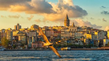
Maltepe is a district in the Asian side of Istanbul, Turkey, on the northern shore of the Sea of Marmara. Its neighbouring districts are Kadıköy to the west, Kartal to the east and Ataşehir to the northwest.
The population grew rapidly from the 70’s onwards when, following the building of the Bosphorus Bridge, it became possible to commute from here to the city. Buses along the D100 highway to the bridge, and minibuses to the ferry docks at Kadıköy now carry lower-middle class commuters (the wealthier preferring to live in smarter areas nearer the city, in Kadıköy itself). These people live either in quiet tree-lined streets of four- to six-storey apartment building with gardens around them, or in modern housing complexes with tennis-courts, children’s playgrounds and security guards on the gate.
Being generally cheaper than Kadıköy, Maltepe is popular with young-families and newlyweds. During the earthquake of 1999 Maltepe suffered badly and many tall apartment blocks needed structural repair, some still bear the cracks of structural damage, something which reduced the price of property in Maltepe considerably. Over the past two years however, prices have risen again despite warnings that Maltepe is always under threat from earthquakes in the future.
The E5 highway cuts through Maltepe and north of the highway is the poorer area of Başıbüyük, a tree-covered hill with a hospital on it (formerly Istanbul’s tuberculosis isolation hospital) and also a large cemetery. But it does have a great view of the coastline and the islands. A large proportion of the residents are from the Black Sea coast and there are some excellent bakeries and Akçaabat kofte restaurants (traditional to that area of Turkey). Maltepe used to border Ümraniye from the northwest between 1992 and 2004. However, the Yeni Çamlıca quarter changed to Ümraniye in 1994 and the Ferhatpaşa quarter passed to Samandıra where bounded to Kartal district in 2004. Ferhatpaşa’s secession led to ending of neighbourhood between Maltepe and Ümraniye.


Comment (0)