Sarıyer

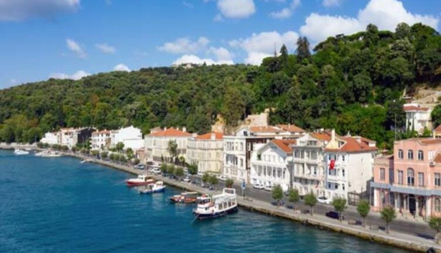
Sarıyer (pronounced [saˈɾɯjeɾ]) is the northernmost district of Istanbul, Turkey, on the European side of the city. The Sarıyer district is a huge area consisting of the villages on the European side of the Bosphorus from Rumelifeneri, down through Tarabya, Yeniköy, İstinye, Emirgan to Rumelihisarı. Sarıyer also administers the Black Sea coast to the west […]

Read More

Pendik

Pendik is a district of Istanbul, Turkey on the Asian side between Kartal and Tuzla, on the Marmara Sea. Home to Sabiha Gökçen International Airport. Population is 711,894. It also neighbours Sultanbeyli, Sancaktepe and Çekmeköy from northwest, Şile from north and Gebze from northeast. Until the 1970s Pendik was a rural area, far from the […]

Read More

Maltepe

Maltepe is a district in the Asian side of Istanbul, Turkey, on the northern shore of the Sea of Marmara. Its neighbouring districts are Kadıköy to the west, Kartal to the east and Ataşehir to the northwest. The population grew rapidly from the 70’s onwards when, following the building of the Bosphorus Bridge, it became […]

Read More

Küçükçekmece

Küçükçekmece is a suburb of Istanbul, Turkey 23 km west of the city, on the European shore of the sea of Marmara. Küçükçekmece lies on the European shore of the Sea of Marmara, on a lagoon named Lake Küçükçekmece. Across the inlet is the district of Avcılar and the campus of Istanbul University. The inlet […]

Read More

Kartal

Kartal is a district of Istanbul, Turkey, located on the Asian side of the city, on the coast of the Marmara Sea between Maltepe and Pendik. Despite being far from the city centre, Kartal is heavily populated (total population of 541,209) (2008 census). The total land area is 147,000 m2 which includes some countryside areas […]

Read More

Kadıköy

Kadıköy known in classical antiquity and during the Roman and Byzantine eras as Chalcedon, is a large, populous, and cosmopolitan district in the Asian side of Istanbul, Turkey, on the northern shore of the Sea of Marmara, facing the historic city centre on the European side of the Bosporus. Kadıköy is also the name of […]

Read More

Kağıthane

Kâğıthane or Glykà Nerà (Γλυκά Νερά Greek pronunciation: [ɡliˈka neˈra], ‘sweet waters’) is an area of Istanbul, Turkey. Formerly a working class district, it has become one of the largest real estate development areas in the city. The district is located on the European side and extends over the shores of Cendere, the stream that […]

Read More

Gaziosmanpaşa

Gaziosmanpaşa (pronounced [ɡaːziosˈmanpasha]; old name: Taşlıtarla) is a developing working class municipality (belediye) and district of Istanbul, Turkey, on its European side. With a population of 400,000 plus, it is one of the most populous districts. In 2009 Gaziosmanpaşa district was divided into three neighborhoods: Gaziosmanpaşa, the central; Sultangazi, the northern part; and Arnavutköy, the […]

Read More

Güngören

Güngören is a small industrial and working class residential district of Istanbul, Turkey. It is located near the district of Bakırköy. Güngören is hard to distinguish from its neighbouring districts in the industrial area north of the E5 highway, districts such as Merter or the poorer parts of Bahçelievler. Like them it has seen a […]

Read More

Esenler

Esenler is a district of Istanbul, Turkey, on its European side. Esenler is mainly densely packed, working class residential in the midst of its industrial neighbouring districts of Gaziosmanpaşa, Güngören and Bağcılar. In the Ottoman times this area, well outside the city walls, was the villages of Litros and Avas, populated by Greek farmers. During […]

Read More